
Weather Alert
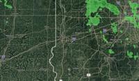
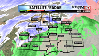
...FLOOD WATCH REMAINS IN EFFECT THROUGH SUNDAY MORNING...

* WHAT...Flooding caused by excessive rainfall continues to be
possible.

* WHERE...Portions of central, east central, north central, south
central, southeast, southwest, and west central Indiana, including
the following counties, in central Indiana, Bartholomew, Boone,
Clinton, Decatur, Hamilton, Hancock, Hendricks, Howard, Johnson,
Madison, Marion, Morgan, Rush, Shelby and Tipton. In east central
Indiana, Delaware, Henry and Randolph. In north central Indiana,
Carroll. In south central Indiana, Brown, Jackson, Lawrence and
Monroe. In southeast Indiana, Jennings. In southwest Indiana,
Daviess, Greene, Knox, Martin and Sullivan. In west central
Indiana, Clay, Fountain, Montgomery, Owen, Parke, Putnam,
Tippecanoe, Vermillion, Vigo and Warren.

* WHEN...Through Sunday morning.

* IMPACTS...Excessive runoff may result in flooding of rivers,
creeks, streams, and other low-lying and flood-prone locations.
Flooding may occur in poor drainage and urban areas. Extensive
street flooding and flooding of creeks and rivers are possible.
Area creeks and streams are running high and could flood with more
heavy rain.

* ADDITIONAL DETAILS...
- Multiple rounds of heavy rainfall will impact central Indiana
through early Sunday. Flash Flood threat increases tonight
into early Saturday morning along and north of the I-70
corridor.
- http://www.weather.gov/safety/flood

PRECAUTIONARY/PREPAREDNESS ACTIONS...

You should monitor later forecasts and be alert for possible Flood
Warnings. Those living in areas prone to flooding should be prepared
to take action should flooding develop.

&&
Weather Alert
...The Flood Warning is extended for the following rivers in
Indiana...Illinois...

Wabash River.

Wildcat Creek near Lafayette.

.Significant flooding is expected to develop along the Wabash River
due to prior rains and additional rounds of heavy rainfall through
Sunday. Additional rainfall of 1.5 to three inches in the upper and
middle Wabash and three to five inches in the lower Wabash is
expected through Sunday. The crest on the Wabash should be in
Lafayette late Sunday night to Monday morning and points downstream
thereafter.

PRECAUTIONARY/PREPAREDNESS ACTIONS...

Turn around, don't drown when encountering flooded roads. Most flood
deaths occur in vehicles.

Additional information is available at www.weather.gov/ind.

The next statement should be issued late tonight by around 330 AM
EDT /230 AM CDT/.

&&

...FLOOD WARNING NOW IN EFFECT FROM SATURDAY MORNING UNTIL FURTHER
NOTICE...

* WHAT...Moderate flooding is forecast.

* WHERE...Wabash River at Clinton.

* WHEN...From Saturday morning until further notice.

* IMPACTS...At 24.0 feet, Critical stage is reached on agricultural
levees in northern Vigo County.  Extensive flooding of
agricultural lands is in progress.  Flooding of low residential
property in southeast Clinton begins.  Some high county roads are
impassable.  River Park at Clinton is completely flooded.  Old SR
63 north of Clinton begins to flood.

* ADDITIONAL DETAILS...
- There is no current observed data.
- Forecast...The river is expected to rise above flood stage
tomorrow morning and continue rising to a crest of 24.4 feet
Monday morning.
- Flood stage is 18.0 feet.
- http://www.weather.gov/safety/flood

&&
Weather Alert
...The Flood Warning is extended for the following rivers in
Indiana...Illinois...

Wabash River.

Wildcat Creek near Lafayette.

.Significant flooding is expected to develop along the Wabash River
due to prior rains and additional rounds of heavy rainfall through
Sunday. Additional rainfall of 1.5 to three inches in the upper and
middle Wabash and three to five inches in the lower Wabash is
expected through Sunday. The crest on the Wabash should be in
Lafayette late Sunday night to Monday morning and points downstream
thereafter.

PRECAUTIONARY/PREPAREDNESS ACTIONS...

Turn around, don't drown when encountering flooded roads. Most flood
deaths occur in vehicles.

Additional information is available at www.weather.gov/ind.

The next statement should be issued late tonight by around 330 AM
EDT /230 AM CDT/.

&&

...FLOOD WARNING NOW IN EFFECT FROM THIS EVENING UNTIL FURTHER
NOTICE...

* WHAT...Moderate flooding is forecast.

* WHERE...Wabash River at Montezuma.

* WHEN...From this evening until further notice.

* IMPACTS...At 24.0 feet, Floodwater is near the top of all
agricultural levees.  Some county roads are impassable.  High
water isolates a few rural residents.  Basement flooding begins
along Water Street in Montezuma.  Medusa Aggregates Company Plant
Number 9 begins to flood.

* ADDITIONAL DETAILS...
- At 11:45 AM EDT Friday the stage was 12.7 feet.
- Forecast...The river is expected to rise above flood stage
this evening and continue rising to a crest of 24.4 feet
Monday morning.
- Flood stage is 14.0 feet.
- http://www.weather.gov/safety/flood

&&
Weather Alert
...The Flood Warning is extended for the following rivers in
Indiana...Illinois...

Wabash River.

Wildcat Creek near Lafayette.

.Significant flooding is expected to develop along the Wabash River
due to prior rains and additional rounds of heavy rainfall through
Sunday. Additional rainfall of 1.5 to three inches in the upper and
middle Wabash and three to five inches in the lower Wabash is
expected through Sunday. The crest on the Wabash should be in
Lafayette late Sunday night to Monday morning and points downstream
thereafter.

PRECAUTIONARY/PREPAREDNESS ACTIONS...

Turn around, don't drown when encountering flooded roads. Most flood
deaths occur in vehicles.

Additional information is available at www.weather.gov/ind.

The next statement should be issued late tonight by around 330 AM
EDT /230 AM CDT/.

&&

...FLOOD WARNING NOW IN EFFECT FROM SATURDAY MORNING UNTIL FURTHER
NOTICE...

* WHAT...Moderate flooding is forecast.

* WHERE...Wabash River at Terre Haute.

* WHEN...From Saturday morning until further notice.

* IMPACTS...At 24.5 feet, Water is at or near critical stages of
many agricultural levees. Flooding of about 10 residential
properties in South Lake area begins. North Lake and Izaak Walton
are now a part of the Wabash River. West Road in northern Vigo
county floods. Flood waters surround homes in lowest areas near
Fort Harrison Country Club. Backwater extends up Lost Creek to
13th Street. Seep water in the U.S. 41 and SR 63 split.

* ADDITIONAL DETAILS...
- At 11:30 AM EDT Friday /10:30 AM CDT Friday/ the stage was
11.9 feet.
- Forecast...The river is expected to rise above flood stage
tomorrow morning and continue rising to a crest of 24.5 feet
Monday evening.
- Flood stage is 16.5 feet.
- http://www.weather.gov/safety/flood

&&


Video Player is loading.
Current Time 0:00
/
Duration 0:00
Loaded: 0%
Stream Type LIVE
Remaining Time -0:00
1x
- Chapters
- descriptions off, selected
- captions settings, opens captions settings dialog
- captions off, selected
This is a modal window.
Beginning of dialog window. Escape will cancel and close the window.
End of dialog window.
Weather Alert
...FLOOD WATCH REMAINS IN EFFECT THROUGH SUNDAY MORNING...

* WHAT...Flooding caused by excessive rainfall continues to be
possible.

* WHERE...Portions of central, east central, north central, south
central, southeast, southwest, and west central Indiana, including
the following counties, in central Indiana, Bartholomew, Boone,
Clinton, Decatur, Hamilton, Hancock, Hendricks, Howard, Johnson,
Madison, Marion, Morgan, Rush, Shelby and Tipton. In east central
Indiana, Delaware, Henry and Randolph. In north central Indiana,
Carroll. In south central Indiana, Brown, Jackson, Lawrence and
Monroe. In southeast Indiana, Jennings. In southwest Indiana,
Daviess, Greene, Knox, Martin and Sullivan. In west central
Indiana, Clay, Fountain, Montgomery, Owen, Parke, Putnam,
Tippecanoe, Vermillion, Vigo and Warren.

* WHEN...Through Sunday morning.

* IMPACTS...Excessive runoff may result in flooding of rivers,
creeks, streams, and other low-lying and flood-prone locations.
Flooding may occur in poor drainage and urban areas. Extensive
street flooding and flooding of creeks and rivers are possible.
Area creeks and streams are running high and could flood with more
heavy rain.

* ADDITIONAL DETAILS...
- Multiple rounds of heavy rainfall will impact central Indiana
through early Sunday. Flash Flood threat increases tonight
into early Saturday morning along and north of the I-70
corridor.
- http://www.weather.gov/safety/flood

PRECAUTIONARY/PREPAREDNESS ACTIONS...

You should monitor later forecasts and be alert for possible Flood
Warnings. Those living in areas prone to flooding should be prepared
to take action should flooding develop.

&&
...The Flood Warning is extended for the following rivers in
Indiana...Illinois...

Wabash River.

Wildcat Creek near Lafayette.

.Significant flooding is expected to develop along the Wabash River
due to prior rains and additional rounds of heavy rainfall through
Sunday. Additional rainfall of 1.5 to three inches in the upper and
middle Wabash and three to five inches in the lower Wabash is
expected through Sunday. The crest on the Wabash should be in
Lafayette late Sunday night to Monday morning and points downstream
thereafter.

PRECAUTIONARY/PREPAREDNESS ACTIONS...

Turn around, don't drown when encountering flooded roads. Most flood
deaths occur in vehicles.

Additional information is available at www.weather.gov/ind.

The next statement should be issued late tonight by around 330 AM
EDT /230 AM CDT/.

&&

...FLOOD WARNING NOW IN EFFECT FROM SATURDAY MORNING UNTIL FURTHER
NOTICE...

* WHAT...Moderate flooding is forecast.

* WHERE...Wabash River at Clinton.

* WHEN...From Saturday morning until further notice.

* IMPACTS...At 24.0 feet, Critical stage is reached on agricultural
levees in northern Vigo County.  Extensive flooding of
agricultural lands is in progress.  Flooding of low residential
property in southeast Clinton begins.  Some high county roads are
impassable.  River Park at Clinton is completely flooded.  Old SR
63 north of Clinton begins to flood.

* ADDITIONAL DETAILS...
- There is no current observed data.
- Forecast...The river is expected to rise above flood stage
tomorrow morning and continue rising to a crest of 24.4 feet
Monday morning.
- Flood stage is 18.0 feet.
- http://www.weather.gov/safety/flood

&&
...The Flood Warning is extended for the following rivers in
Indiana...Illinois...

Wabash River.

Wildcat Creek near Lafayette.

.Significant flooding is expected to develop along the Wabash River
due to prior rains and additional rounds of heavy rainfall through
Sunday. Additional rainfall of 1.5 to three inches in the upper and
middle Wabash and three to five inches in the lower Wabash is
expected through Sunday. The crest on the Wabash should be in
Lafayette late Sunday night to Monday morning and points downstream
thereafter.

PRECAUTIONARY/PREPAREDNESS ACTIONS...

Turn around, don't drown when encountering flooded roads. Most flood
deaths occur in vehicles.

Additional information is available at www.weather.gov/ind.

The next statement should be issued late tonight by around 330 AM
EDT /230 AM CDT/.

&&

...FLOOD WARNING NOW IN EFFECT FROM THIS EVENING UNTIL FURTHER
NOTICE...

* WHAT...Moderate flooding is forecast.

* WHERE...Wabash River at Montezuma.

* WHEN...From this evening until further notice.

* IMPACTS...At 24.0 feet, Floodwater is near the top of all
agricultural levees.  Some county roads are impassable.  High
water isolates a few rural residents.  Basement flooding begins
along Water Street in Montezuma.  Medusa Aggregates Company Plant
Number 9 begins to flood.

* ADDITIONAL DETAILS...
- At 11:45 AM EDT Friday the stage was 12.7 feet.
- Forecast...The river is expected to rise above flood stage
this evening and continue rising to a crest of 24.4 feet
Monday morning.
- Flood stage is 14.0 feet.
- http://www.weather.gov/safety/flood

&&
...The Flood Warning is extended for the following rivers in
Indiana...Illinois...

Wabash River.

Wildcat Creek near Lafayette.

.Significant flooding is expected to develop along the Wabash River
due to prior rains and additional rounds of heavy rainfall through
Sunday. Additional rainfall of 1.5 to three inches in the upper and
middle Wabash and three to five inches in the lower Wabash is
expected through Sunday. The crest on the Wabash should be in
Lafayette late Sunday night to Monday morning and points downstream
thereafter.

PRECAUTIONARY/PREPAREDNESS ACTIONS...

Turn around, don't drown when encountering flooded roads. Most flood
deaths occur in vehicles.

Additional information is available at www.weather.gov/ind.

The next statement should be issued late tonight by around 330 AM
EDT /230 AM CDT/.

&&

...FLOOD WARNING NOW IN EFFECT FROM SATURDAY MORNING UNTIL FURTHER
NOTICE...

* WHAT...Moderate flooding is forecast.

* WHERE...Wabash River at Terre Haute.

* WHEN...From Saturday morning until further notice.

* IMPACTS...At 24.5 feet, Water is at or near critical stages of
many agricultural levees. Flooding of about 10 residential
properties in South Lake area begins. North Lake and Izaak Walton
are now a part of the Wabash River. West Road in northern Vigo
county floods. Flood waters surround homes in lowest areas near
Fort Harrison Country Club. Backwater extends up Lost Creek to
13th Street. Seep water in the U.S. 41 and SR 63 split.

* ADDITIONAL DETAILS...
- At 11:30 AM EDT Friday /10:30 AM CDT Friday/ the stage was
11.9 feet.
- Forecast...The river is expected to rise above flood stage
tomorrow morning and continue rising to a crest of 24.5 feet
Monday evening.
- Flood stage is 16.5 feet.
- http://www.weather.gov/safety/flood

&&